
Other interesting stuff and programming
|
HDR tone mapping using the CUDA programming environment | [package] | |
|
I have been playing around quite seriously with the CUDA programming
environment. There is a little app called cudaGLview that reads
HDR imaging data and applies tone mapping operators to it. GPGPU
processing allows to do this in realtime with up to 2 gigapixel per
second.
The intention of this experiment was to learn about memory bandwidth and processing resource allocation on DX10-style graphics cards. The CUDA environment provides a very convenient yet much more detailled view than before on the hardware. Check it out!
The code is released on SourceForge for the Linux platform. |
|||
|
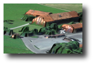
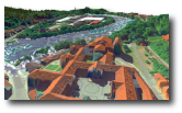
TeReX - Special topics in terrain rendering | [archive] | |
|
Lately, I am back to terrain rendering. I am looking for solutions to
common problems in displaying aerial images on sampled heightfields. You
all know these techniques from terrain viewers like Google Earth.
The work focuses on improving the visual quality of the terrain. The TeReX renderer uses the tiling approach from Jens Schneiders Terrain paper with a number of improvements:
Recent features under development:
|
|||